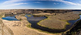
 Warning: Fun Science Alert! When the Ice Age was on, there was a huge lobe of glacial ice that extended down into Central Washington, called the Okanogan Lobe, which diverted the course of the Columbia River. In the meantime, there was another huge lobe of glacial ice that blocked off the drainage of the Clark Fork, Spokane, Pend Oreille, and St. Joe Rivers and formed a huge lake in Montana called Glacial Lake Missoula. When all that water backed up in the Rockies busted loose, it came raging down the foothills and slammed into the Okanogan Ice Lobe and went sluicing down the diverted course of the Columbia which we commonly know as Sun Lakes Coulee. (Officially Lower Grand Coulee) As the water came rushing through it carved a "coulee" or valley right down through the layers of basalt rock and left a rather dramatic dry waterfall, once ten times the size of Niagara Falls, with beautiful Dry Falls Lake at its base, which is the first lake in the Sun Lakes chain.
 About 100 miles west of Spokane on Highway 2, turn south on Highway 17 which runs right down through the coulee. The first point of interest you will come to on this leg of the journey is the Dry Falls Overlook & Interpretive Center. This is a great place to introduce your kids to the concepts of climate cycles and the awesome power of nature. Another thing to marvel at here, is the beautiful rock masonry structures built by the Civilian Conservation Corps in the 1930's. There were some tremendous craftsmen on those crews.The Interpretive Center is open from 9 a.m. to 4 p.m. daily, except holidays, and they have restrooms.

No comments:
Post a Comment